Cafe nearby IICS Cafe
Bhutan
Cafe nearby IICS Cafe
IICS Cafe
CFQJ+PPJ, Kungarapten, Bhutan
contacts phone
:
+975
Latitude:
27.4393359
, Longitude:
90.4817569
larger map & directions
read more
nearest Cafe
9.58 km
Venkateshwara Temple
GC7M+MC9, Trongsa
Cafe
Food
Point of interest
Establishment
read more
20.352 km
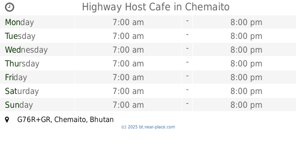
Highway Host Cafe
G76R+GR, Chemaito
Cafe
Point of interest
Food
Store
Establishment
read more
28.982 km
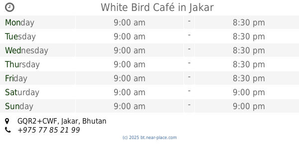
White Bird Café
GQR2+CWF, Jakar
Cafe
Point of interest
Food
Establishment
read more
29.095 km
Valley Cafe
Bumthang, Chamkhar
Cafe
Food
Point of interest
Establishment
read more
29.567 km
Cafe Perk
GQX3+WQP, Jakar
Cafe
Food
Point of interest
Establishment
read more
29.588 km
Kinga dendrup
HP8V+XVW, Jakar
Cafe
Food
Point of interest
Establishment
read more
29.64 km
oppa cafe
chamkhar, chamkhar lam
Cafe
Food
Point of interest
Establishment
read more
29.64 km
Valley cafe
JMRG+PWM, Dhur
Cafe
Store
Point of interest
Food
Establishment
read more
29.64 km
Churs Cafe
Chamkhar, Gongkhar
Cafe
Food
Point of interest
Establishment
read more
29.644 km
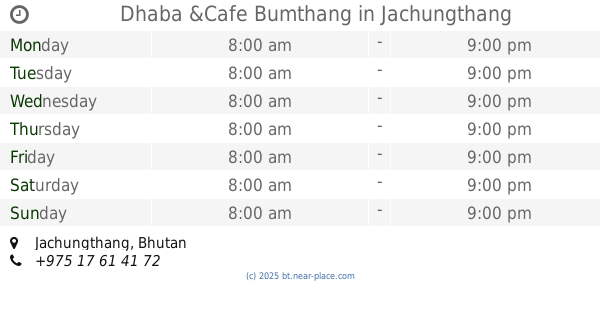
Dhaba &Cafe Bumthang
Jachungthang
Cafe
Point of interest
Food
Store
Establishment
read more
29.711 km
PEE CEE snooker chamkhar town
GQX4+RFG, Jakar
Cafe
Food
Point of interest
Establishment
read more
29.817 km
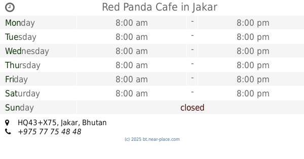
Red Panda Cafe
HQ43+X75, Jakar
Cafe
Food
Point of interest
Establishment
read more
29.83 km
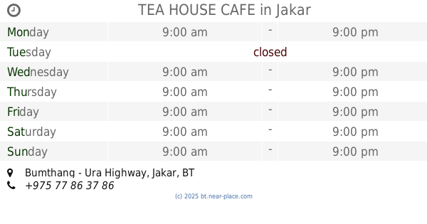
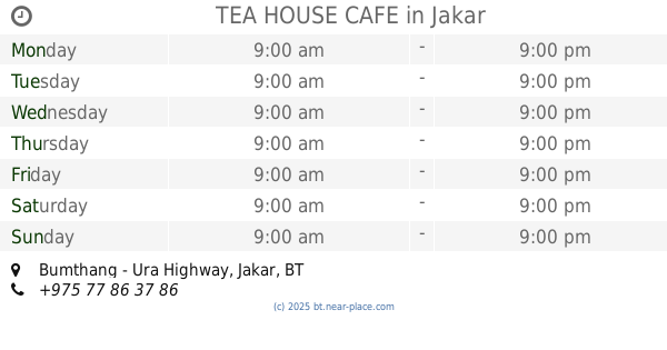
TEA HOUSE CAFE
HQ24+6R2, Bumthang - Ura Highway, Jakar
Cafe
Food
Point of interest
Establishment
read more
29.83 km
TEA HOUSE CAFE
Bumthang - Ura Highway, Jakar
Cafe
read more
29.984 km
NHDRC cafeteria
HQ72+MFQ, Unnamed Road, Jakar
Cafe
Food
Point of interest
Establishment
read more
59.68 km
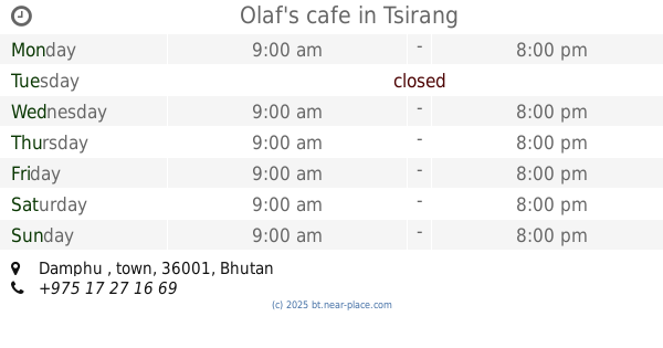
Olaf's cafe
Damphu , town
Cafe
Food
Point of interest
Establishment
read more
61.44 km
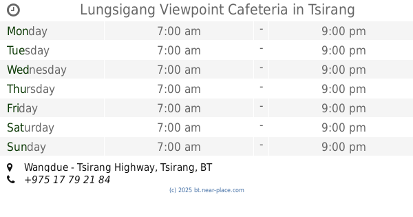
Lungsigang Viewpoint Cafeteria
Wangdue - Tsirang Highway
Cafe
Food
Point of interest
Establishment
read more
📑
all categories
Accounting
Administrative area level 1
Airport
Art gallery
Atm
Bakery
Bank
Bar
Beauty salon
Book store
Bus station
Cafe
Campground
Car dealer
Car rental
Car repair
Car wash
Cemetery
Church
City hall
Clothing store
Convenience store
Country
Courthouse
Dentist
Department store
Doctor
Electronics store
Embassy
Establishment
Finance
Fire station
Food
Furniture store
Gas station
General contractor
Grocery or supermarket
Gym
Hair care
Hardware store
Health
Hindu Temple
Home goods store
Hospital
Insurance agency
Intersection
Jewelry store
Laundry
Lawyer
Library
Liquor store
Local government office
Locality
Lodging
Meal takeaway
Mosque
Movie theater
Museum
Neighborhood
Night club
Park
Parking
Pet store
Pharmacy
Place of worship
Point of interest
Police
Post office
Premise
Real estate agency
Restaurant
Route
School
Shoe store
Shopping mall
Spa
Stadium
Storage
Store
Supermarket
Taxi stand
Travel agency
University
Veterinary care
Zoo
sublocality level 1
↑