School nearby ELC High School
Bhutan
School nearby ELC High School
ELC High School
Chuja Lam,, Thimphu, Bután
contacts phone
:
+975
website:
www.facebook.com
Latitude:
27.4648059
, Longitude:
89.6515295
larger map & directions
read more
nearest School
531 m
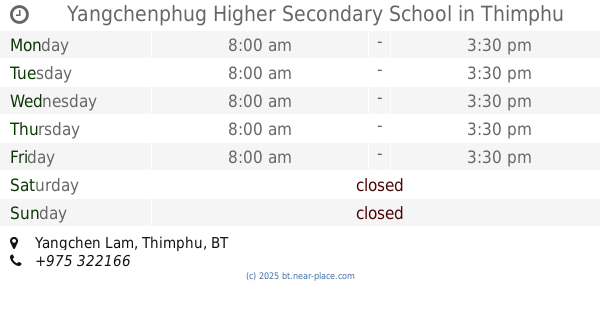
Yangchenphug Higher Secondary School
Yangchen Lam, Thimphu
School
read more
543 m
Yangchenphu Higher Secondery School
Yangchen Lam, Thimphu
School
read more
745 m
Lungtenzampa Middle Secondary School
Yangchen Lam, Thimphu
School
read more
800 m
Loselling Midde Secondary School
Chang Ji Ji Lam, Thimphu
School
read more
823 m
Thimphu Primary School (TPS)
Thimphu
School
read more
1.006 km
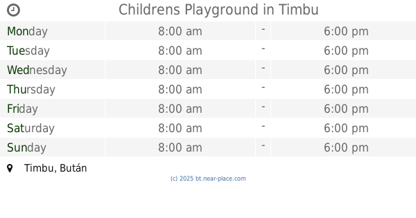
Childrens Playground
Thimphu
School
read more
1.103 km
Changzamtok Lower Secondary School
Gongphel Lam, Thimphu
School
read more
1.132 km
Global Retail Academy
Hebi Lam-3, Thimphu
School
read more
1.258 km
Gangjung Driving Centre of Excellence
Gongdzin Lam 23, Thimphu
School
read more
1.361 km
IITM (Institute of Information Technology and Management
Menkhang Lam, Thimphu
School
read more
1.43 km
Druk School
Gakyi Lam, Thimphu
School
read more
1.499 km
Changzamtog Secondary School
Thimphu
School
read more
1.53 km
Etho Metho School
Doeboom Lam, Thimphu
School
read more
1.558 km
Institute For Professional Studies
Thimphu
School
read more
1.788 km
Kelki Higher Secondary School
Doeboom Lam
School
read more
2.172 km
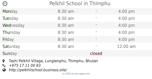
Pelkhil School
Tashi Pelkhil Village, Lungtenphu, Thimphu
School
read more
2.64 km
Early Learning Center
Thimphu
School
read more
3.415 km
Zilukha Middle Secondary School
Gaden Lam, Thimphu
School
read more
3.422 km
Faculty of Traditional Medicine
Menri Lam, Thimphu
School
read more
5.728 km
Nima Higher Secondary School
Dechhen Lam, Thimphu
School
read more
22.554 km
Dotay Lower Sacondary School
Dotay,
School
read more
23.752 km
Woochu Lower Secondary School
Paro
School
read more
23.783 km
Ugyen Academy Higher Secondary School
Khuruthang
School
read more
26.58 km
Mendhagang Primary SCHOOL
Punakha
School
read more
📑
all categories
Accounting
Administrative area level 1
Airport
Art gallery
Atm
Bakery
Bank
Bar
Beauty salon
Book store
Bus station
Cafe
Campground
Car dealer
Car rental
Car repair
Car wash
Cemetery
Church
City hall
Clothing store
Convenience store
Country
Courthouse
Dentist
Department store
Doctor
Electronics store
Embassy
Establishment
Finance
Fire station
Food
Furniture store
Gas station
General contractor
Grocery or supermarket
Gym
Hair care
Hardware store
Health
Hindu Temple
Home goods store
Hospital
Insurance agency
Intersection
Jewelry store
Laundry
Lawyer
Library
Liquor store
Local government office
Locality
Lodging
Meal takeaway
Mosque
Movie theater
Museum
Neighborhood
Night club
Park
Parking
Pet store
Pharmacy
Place of worship
Point of interest
Police
Post office
Premise
Real estate agency
Restaurant
Route
School
Shoe store
Shopping mall
Spa
Stadium
Storage
Store
Supermarket
Taxi stand
Travel agency
University
Veterinary care
Zoo
sublocality level 1
↑