Atm nearby BDBL ATM
Bhutan
Atm nearby BDBL ATM
BDBL ATM
Bhutan
contacts phone
:
+975
Latitude:
27.2811946
, Longitude:
91.5168304
larger map & directions
read more
nearest Atm
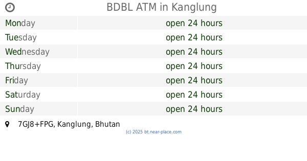
BDBL ATM
7GJ8+FPG, Kanglung
Atm
Finance
Point of interest
Establishment
read more
1.148 km
Bank of Bhutan, ATM
Unnamed Road
Atm
read more
1.212 km
Bank of Bhutan, ATM
7GQG+C8V, Unnamed Road, Kanglung
Atm
Finance
Point of interest
Establishment
read more
6.92 km
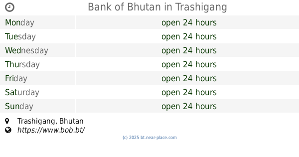
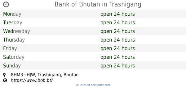
Bank of Bhutan
Trashigang
Atm
read more
6.926 km
Bank of Bhutan
8HM3+HJW, Trashigang
Atm
Finance
Point of interest
Establishment
read more
16.88 km
Bank of Bhutan, eBranch
4HPC+Q4R, Wamrong
Atm
Finance
Point of interest
Establishment
read more
17.365 km
BOB ATM
9M69+86P, Radi
Atm
Finance
Point of interest
Establishment
read more
17.394 km
BNB ATM
9M59+VM7, Unnamed Road, Radi
Atm
Point of interest
Finance
Establishment
read more
27.499 km
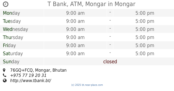
T Bank, ATM, Mongar
Mongar
Atm
read more
27.499 km
T Bank, ATM, Mongar
76GQ+FCQ, Mongar
Atm
Finance
Point of interest
Establishment
read more
32.073 km
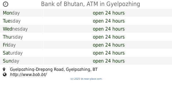
Bank of Bhutan, ATM
Gyelpozhing-Drepong Road
Atm
Finance
Point of interest
Establishment
read more
33.933 km
BNBL ATM
Lingmethang
Atm
read more
33.933 km
BNBL ATM
756F+9M8, Lingmethang
Atm
Finance
Point of interest
Establishment
read more
36.415 km
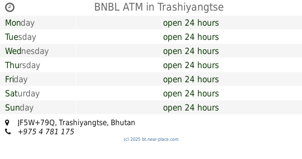
BNBL ATM
JF5W+79Q
Atm
Finance
Point of interest
Establishment
read more
36.614 km
BOB ATM
JF6W+2V6, Tashigang Road, Trashiyangtse
Atm
Finance
Point of interest
Establishment
read more
36.614 km
BDBL ATM
JF6X+25J, Trashiyangtse
Atm
Point of interest
Finance
Establishment
read more
46.726 km
BNBL ATM
VF7F+433, Deothang
Atm
Point of interest
Finance
Establishment
read more
53.52 km
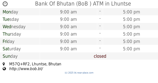
Bank Of Bhutan (BoB ) ATM
M57Q+RF2, Lhuntse
Atm
Finance
Point of interest
Establishment
read more
55.306 km
BNBL ATM
R6WX+27F, Nganglam
Atm
Finance
Point of interest
Establishment
read more
📑
all categories
Accounting
Administrative area level 1
Airport
Art gallery
Atm
Bakery
Bank
Bar
Beauty salon
Book store
Bus station
Cafe
Campground
Car dealer
Car rental
Car repair
Car wash
Cemetery
Church
City hall
Clothing store
Convenience store
Country
Courthouse
Dentist
Department store
Doctor
Electronics store
Embassy
Establishment
Finance
Fire station
Food
Furniture store
Gas station
General contractor
Grocery or supermarket
Gym
Hair care
Hardware store
Health
Hindu Temple
Home goods store
Hospital
Insurance agency
Intersection
Jewelry store
Laundry
Lawyer
Library
Liquor store
Local government office
Locality
Lodging
Meal takeaway
Mosque
Movie theater
Museum
Neighborhood
Night club
Park
Parking
Pet store
Pharmacy
Place of worship
Point of interest
Police
Post office
Premise
Real estate agency
Restaurant
Route
School
Shoe store
Shopping mall
Spa
Stadium
Storage
Store
Supermarket
Taxi stand
Travel agency
University
Veterinary care
Zoo
sublocality level 1
↑