Campground nearby Yongkola Birding campsite
Bhutan
Campground nearby Yongkola Birding campsite
Yongkola Birding campsite
8557+5H4, Mongar, Bhutan
contacts phone
:
+975
Latitude:
27.3078915
, Longitude:
91.1639627
larger map & directions
read more
nearest Campground
18.08 km
Serzhong
Thrisa, Shingkhar
Campground
Park
Lodging
Point of interest
Establishment
read more
20.675 km
Chulingkai Brok
6X5Q+43C, Nimgong
Campground
Park
Lodging
Point of interest
Establishment
read more
20.782 km
Dongtey
Thrisa, Shingkhar
Campground
Park
Lodging
Point of interest
Establishment
read more
21.036 km
Charchar La
Thrisa, Shingkhar
Campground
Lodging
Park
Point of interest
Establishment
read more
21.905 km
Chaling
Thrisa, Shingkhar
Campground
Park
Lodging
Point of interest
Establishment
read more
23.224 km
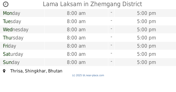
Lama Laksam
Thrisa, Shingkhar
Campground
Lodging
Park
Point of interest
Establishment
read more
23.729 km
Gayzamchhu
CXH8+G9F, Ura
Campground
Park
Lodging
Point of interest
Establishment
read more
32.939 km
Pimi
H2JJ+2Q4
Campground
Park
Lodging
Point of interest
Establishment
read more
34.712 km
Upper Pangthang
7GH7+HG2, Unnamed Road, Kanglung
Campground
Lodging
Park
Point of interest
Establishment
read more
37.694 km
Mishingzor
6GMP+QG8, Trashigang
Campground
Lodging
Park
Point of interest
Establishment
read more
39.717 km
Phokpey
JW4V+G2, Tang Valley
Campground
Lodging
Park
Point of interest
Establishment
read more
40.381 km
pemagatshel dzongkhag guesthouse
2CJH+JHC, Unnamed Road, Pemagatsel
Campground
Lodging
Park
Point of interest
Establishment
read more
44.25 km
Pana tse
P62Q+4M, Khoma
Campground
Park
Lodging
Point of interest
Establishment
read more
44.484 km
Baru Thang
P62V+P6, Khoma
Campground
Park
Lodging
Point of interest
Establishment
read more
45.012 km
DOLEPCHEN RECEPTION POINT
2F9J+FXW, Unnamed Road, Narphu
Campground
Park
Lodging
Point of interest
Establishment
read more
51.685 km
Resting place (Canopy)
MFV3+RX, Trashiyangtse
Campground
Park
Lodging
Point of interest
Establishment
read more
📑
all categories
Accounting
Administrative area level 1
Airport
Art gallery
Atm
Bakery
Bank
Bar
Beauty salon
Book store
Bus station
Cafe
Campground
Car dealer
Car rental
Car repair
Car wash
Cemetery
Church
City hall
Clothing store
Convenience store
Country
Courthouse
Dentist
Department store
Doctor
Electronics store
Embassy
Establishment
Finance
Fire station
Food
Furniture store
Gas station
General contractor
Grocery or supermarket
Gym
Hair care
Hardware store
Health
Hindu Temple
Home goods store
Hospital
Insurance agency
Intersection
Jewelry store
Laundry
Lawyer
Library
Liquor store
Local government office
Locality
Lodging
Meal takeaway
Mosque
Movie theater
Museum
Neighborhood
Night club
Park
Parking
Pet store
Pharmacy
Place of worship
Point of interest
Police
Post office
Premise
Real estate agency
Restaurant
Route
School
Shoe store
Shopping mall
Spa
Stadium
Storage
Store
Supermarket
Taxi stand
Travel agency
University
Veterinary care
Zoo
sublocality level 1
↑